Corinth Report: Nezi Field 2007 by Heidi Broome-Raines (2007-04-30 to 2007-05-18) | Collection: | | Corinth | | Type: | | Report | | Name: | | Nezi Field 2007 by Heidi Broome-Raines (2007-04-30 to 2007-05-18) | | Title: | | Middle Roman to Middle Byzantine Contexts in the Area North of Nezi Field | | Context: | | Nezi Field, context 5021 | | | | Nezi Field, context 5066 | | | | Nezi Field, context 5064 | | | | Nezi Field, context 5033 | | | | Nezi Field, context 5063 | | | | Nezi Field, context 5038 | | | | Nezi Field, context 5002 | | | | Nezi Field, context 5048 | | | | Nezi Field, context 5045 | | | | Nezi Field, context 5028 | | | | Nezi Field, context 5078 | | | | Nezi Field, context 5020 | | | | Nezi Field, context 5009 | | | | Nezi Field, context 5057 | | | | Nezi Field, context 5069 | | | | Nezi Field, context 5065 | | | | Nezi Field, context 5011 | | | | Nezi Field, context 5007 | | | | Nezi Field, context 5014 | | | | Nezi Field, context 5032 | | | | Nezi Field, context 5004 | | | | Nezi Field, context 5034 | | | | Nezi Field, context 5016 | | | | Nezi Field, context 5047 | | | | Nezi Field, context 5080 | | | | Nezi Field, context 5017 | | | | Nezi Field, context 5023 | | | | Nezi Field, context 5061 | | | | Nezi Field, context 5050 | | | | Nezi Field, context 5015 | | | | Nezi Field, context 5035 | | | | Nezi Field, context 5052 | | | | Nezi Field, context 5027 | | | | Nezi Field, context 5025 | | | | Nezi Field, context 5005 | | | | Nezi Field, context 5079 | | | | Nezi Field, context 5040 | | | | Nezi Field, context 5059 | | | | Nezi Field, context 5046 | | | | Nezi Field, context 5018 | | | | Nezi Field, context 5037 | | | | Nezi Field, context 5006 | | | | Nezi Field, context 5039 | | | | Nezi Field, context 5044 | | | | Nezi Field, context 5012 | | | | Nezi Field, context 5062 | | | | Nezi Field, context 5056 | | | | Nezi Field, context 5041 | | | | Nezi Field, context 5081 | | | | Nezi Field, context 5003 | | | | Nezi Field, context 5054 | | | | Nezi Field, context 5055 | | | | Nezi Field, context 5029 | | | | Nezi Field, context 5008 | | | | Nezi Field, context 5077 | | | | Nezi Field, context 5026 | | | | Nezi Field, context 5060 | | | | Nezi Field, context 5075 | | | | Nezi Field, context 5022 | | | | Nezi Field, context 5073 | | | | Nezi Field, context 5013 | | | | Nezi Field, context 5058 | | | | Nezi Field, context 5030 | | | | Nezi Field, context 5043 | | | | Nezi Field, context 5071 | | | | Nezi Field, context 5070 | | | | Nezi Field, context 5042 | | | | Nezi Field, context 5082 | | | | Nezi Field, context 5019 | | | | Nezi Field, context 5051 | | | | Nezi Field, context 5068 | | | | Nezi Field, context 5074 | | | | Nezi Field, context 5072 | | | | Nezi Field, context 5036 | | | | Nezi Field, context 5053 | | | | Nezi Field, context 5031 | | | | Nezi Field, context 5024 | | | | Nezi Field, context 5076 | | | | Nezi Field, context 5049 | | | | Nezi Field, context 5001 | | | | Nezi Field, context 5010 | | | | Nezi Field, context 5067 | | Area: | | Nezi Field | | Site: | | Corinth | | City: | | Ancient Corinth | | Country: | | Greece | | References: | | Baskets (82)
|
INTRODUCTION
For three weeks, I, Heidi Broome-Raines, worked in the area designated “North of Nezi,” conducting cleaning operations and new excavation. The baskets for which I am responsible are B 5001-5082. This area is located between 282.7 E to the east and 266.2 E to the west; 1023.2 N to the north and 1016.1 N to the south; it is immediately north of the “Nezi Field.” My team consisted of myself as trenchmaster, Panagiotis Kakouros as pickman, Konstantinos Arberoris as shovelman, and Dimitris Papaioannou as barrowman and dry sieve operator. Alicia Carter was my supervisor. The excavations were directed by Dr. G.D.R. Sanders.
The objectives of our work in this area were to clean the area, to clarify the situation as left by the 1961 excavators (see NB228); to create a relative (and, as much as possible, absolute) chronology for the walls and features; and to eliminate the possibility of Late Medieval levels in the area.
The area was partially excavated in 1961, but the records (NB 228) left by the excavators are paltry and difficult to associate with the state of the area when we began working here. We have reused some of their terminology in order to simplify the differentiation of rooms, walls, and features, and I have added only descriptive names, pending further excavation and interpretation in later years.
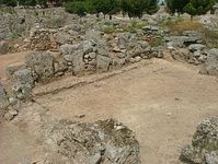
Work began in “Room E,” (1021.2 – 1016.38 N, 278.16 – 282.63 E) so designated by the 1961 excavators, where we concentrated on a pit in the northwest corner of the room, and a drain feature running along the west side of the room from north to south. We were testing for the presence of medieval material in this room. With the same objective, we then moved to neighboring Room F, which is a large rectangular area nominally divided by the “potatostone wall” and a large pit, “Bothros 6.” We started in the east half of the room, excavating stratographically an area which had been left as if it were a wall by the previous excavators. Then we shifted our focus to the west half of Room F (to which I refer here as FW, located at 1015.3 – 1020 N, 266.53 – 271.13 E), where completed the excavation of a large pit, “Bothros 7,” which had been partially excavated in 1961, and nearby deposits. When our contexts seemed to continue under the north wall of Room F, we removed the last phase of the wall and continued excavating under and on the north side of it, in an area I refer to (in the notebooks) as “the room north of Room F, west half,” but in this report, NFW (1020 – 1023 N, 266.2 – 271 E).
Excavation in these areas was complicated by the 1961 excavations, both because the recording of those excavations does not shed much light on the work done at that time, and because the techniques used are not compatible with ours (such as a deep wall-chasing trench in NFW); we were rewarded by the appearance in a small area of sixty coins, the majority of Imperial Roman date (fourth to sixth centuries AC) but also including a remarkably well-preserved Trajanic dupondius which has been added to the Corinth Study Collection. I have been able to phase a number of the walls, as well as to establish a relative chronology for the excavated area.
MIDDLE ROMAN
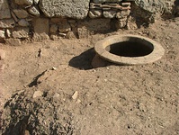
In Room E, there is at least one (although possibly two) Middle Roman phases. The installation of the drain feature (B 5008 – 5010, 5014, 5035; at 1016.34 – 1021.51 N, 278.21 – 279.25 E) has been dated based on pottery and small finds to the second half of the third century AC. Although we did not excavate outside the room itself, I believe that doing so would show that the drain leads either to the well south of the room and practically in line with the drain, or the large street sewer that lies under the sidewalk of the north/south road only a few meters east of Room E. Associating this drain with one of those features is a possible objective for future excavation in the area south of Room E.
The drain is cut by a rubbish pit, measuring 1.07m on its longest axis, and containing mostly cookware fragments but no bones (B 5004 – 5005, 5012; at 1019.69 – 1020.56 N, 279.19 – 280.13 E); the drain is also cut by a section of the north wall of the room, which, although not securely dated based on its own pottery, is cut by the pit. Therefore, the north wall was built after the drain but before the pit. I cannot assign the date of the wall securely either to the Middle or Late Roman period, however.
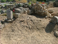
To the west of Room E, the destruction context in NFW (B 5069, 5082) has been dated on pottery evidence to the Middle Roman period. It underlies several other contexts which were also dated to later years of the Middle Roman period. This context appears to continue under the north wall of FW, which suggests to me that further excavation in the northern end of FW, in line with this destruction context, will reveal the extent of this destruction to the south. At present, based on a very small area, it is difficult to speculate about the destruction that caused a fall of rooftiles (all broken but in large pieces), burned mudbrick, charred potsherds, and carbon jumbled together and strewn across the surface of the east-central area of NFW.
The crosswall which runs north/south through NFW forms a boundary to the west for the destruction context. Although this is not a decisive interpretation, it seems likely that the crosswall predates the destruction that caused the rooftile fall, because while soil from the west half of the room continues over the crosswall where it has been destroyed, the destruction context stops abruptly at the east face of the crosswall. If the crosswall had already been destroyed when the destruction took place, or if they were contemporaneous, I would expect some of the destruction context to be present over the destroyed part of the wall. Since I did not find any, I am tentatively giving a relative chronology of the events: the crosswall was built before the Middle Roman destruction in the east half of NFW; followed by that destruction; followed by the demolition of the crosswall and the deposition of the soil in the west half of the room which continues over the destroyed wall (B 5078). The wall is in situ and I did not find any foundation trenches for it, so it has produced no datable material to compare with the Middle Roman pottery in the destruction level.
LATE ROMAN
A substantial clay layer (B 5011, 5013) in Room E has been dated on pottery and coins to the second half of the sixth century, AC. Although this layer could be a floor, the fact that it pools in one corner and stretches “fingers” into the room suggests to me that it is rather an accumulation of clay building material which has decomposed and settled.
In the east half of Room F (“FE,” at 1016.14 – 1020.29 N, 271.71 – 277.67 E), we limited our activity to excavating stratographically a wall-shaped area left in situ by the 1961 excavators. In a series of baskets (B 5015 – 5026) we removed successive layers: all except the cleaning basket were Late Roman. The lowermost datable stratum (B 5022) was dated to the middle of the sixth century AC.
Our goal in excavating this area, in addition to establishing the stratigraphy in the only place where it has survived at such high elevations, was to phase three walls in the area: the north wall of FE, the east wall of Room F, and the west wall of Room E. The north wall of FE appeared under seven layers of deposited soils. The east wall of Room F runs over and postdates the north wall of Room F. However, none of this wall masonry has been dated securely. I was not able to establish a chronological relationship between the west wall of Room E and the other two walls.
The north wall of FW has been shown to have at least three phases. The first of these phases, discussed above, involves the blocks associated with the Middle Roman or earlier crosswall which runs perpendicular to this wall and is included within it; the second, and now Late Roman, is the greater part of the wall itself, which appears to have been built up on either side of the block of the crosswall. This block juts out to the north several centimeters further than the rest of the north wall of Room F, suggesting that it was not part of the construction of the wall, but rather was already there. Further supporting this is the fact that the destruction context runs under the second phase of the wall but stops short at the crosswall. The wall has been interrupted at the very east end of FW, in a way which suggests a doorway. The third and final phase of this wall is the filling in of the doorway with blocks and rubble (B 5051), in a markedly lesser quality of construction, which I have not left in situ. This phase also belongs to the Late Roman period.
The foundation trench (B 5060, 5061) for the west wall of FW has also been dated to Late Roman by a coin dating securely to 367-375 AC. It appears to have been built after the north wall of FW, but further excavation should clarify this hypothesis.
The potatostone wall, which is only preserved in the north quarter of Room F, serving as the dividing line between the east and west halves, may belong to this period. A large orthostate block is visible in the matrix of this wall, but in line with the north wall of Room FW. Because it is the only such block visible in the wall, and because of its position, I have related the two as follows: the orthostate block remained in place from the second phase of the N wall of Room F (see above) and was built up to on both sides in the form of the potatostone wall. I have not excavated the pit called “Bothros 6,” and cannot make any statement about the relationship between the two; but it should be noted that the potatostone wall breaks off just at the north extent of the pit.
MIDDLE BYZANTINE
Bothros 7, the large pit which had already been partially excavated in part in 1961, has been convincingly dated on pottery to the Middle Byzantine period, which can perhaps be dated as specifically as 1080 – 1100 AC.
No material culture excavated in any of my eighty-two contexts can be dated later than Middle Byzantine.
CONCLUSION
The excavation of North of Nezi has raised several new questions: What was the extent of the Middle Roman destruction context in NFW? Further excavation would also be repaid by clarifying the relationship between the walls and pits. The next logical step would be to remove the potatostone wall, which we have identified as significantly later in date than the surrounding contexts. I would suggest excavation of Bothros 6 and of the pit into which the large pithos is sunk, as well as the clay floor in FE. Eventually it should be possible to identify uses for the area at periods as late as Late Roman.
We have settled several questions as well. Any levels later than Middle Byzantine have been removed by the 1961 excavators, and we should not expect to find anything dating to later periods anywhere in the excavated areas. However, Bothros 6 and the robbing trench at the southern extremity of FW may yet reveal medieval levels.
Further study of the finds, perhaps in combination with additional excavation in the area, may reveal the significance of the large concentration of Late Roman coins in NFW. When the samples I collected have been water sieved, there may be additional information about use of space and structure, especially in areas with a great deal of ash and other evidence of burning. The perimeter of the excavation can still be widened, perhaps not to the north, but with assuredly better stratigraphy immediately to the south in Nezi Field, currently excavated down to Frankish levels, should excavation in that area continue down to elevations like my own. Widening the excavated area would contribute to our understanding of the history of occupation and function of the space, which at present is limited by our narrow perimeter.
|