Corinth Report: Nezi Field 2007 by Lina Kokkinou and Angela Ziskowski (2007-05-21 to 2007-06-09) | Collection: | | Corinth | | Type: | | Report | | Name: | | Nezi Field 2007 by Lina Kokkinou and Angela Ziskowski (2007-05-21 to 2007-06-09) | | Title: | | Byzantine to Early Modern period in the southern end of Nezi Field | | Context: | | Nezi Field, context 206 | | | | Nezi Field, context 148 | | | | Nezi Field, context 188 | | | | Nezi Field, context 129 | | | | Nezi Field, context 54 | | | | Nezi Field, context 153 | | | | Nezi Field, context 214 | | | | Nezi Field, context 175 | | | | Nezi Field, context 217 | | | | Nezi Field, context 187 | | | | Nezi Field, context 226 | | | | Nezi Field, context 172 | | | | Nezi Field, context 147 | | | | Nezi Field, context 210 | | | | Nezi Field, context 199 | | | | Nezi Field, context 150 | | | | Nezi Field, context 159 | | | | Nezi Field, context 213 | | | | Nezi Field, context 149 | | | | Nezi Field, context 179 | | | | Nezi Field, context 197 | | | | Nezi Field, context 182 | | | | Nezi Field, context 202 | | | | Nezi Field, context 160 | | | | Nezi Field, context 200 | | | | Nezi Field, context 131 | | | | Nezi Field, context 185 | | | | Nezi Field, context 218 | | | | Nezi Field, context 204 | | | | Nezi Field, context 181 | | | | Nezi Field, context 219 | | | | Nezi Field, context 208 | | | | Nezi Field, context 209 | | | | Nezi Field, context 167 | | | | Nezi Field, context 142 | | | | Nezi Field, context 223 | | | | Nezi Field, context 115 | | | | Nezi Field, context 212 | | | | Nezi Field, context 186 | | | | Nezi Field, context 198 | | | | Nezi Field, context 104 | | | | Nezi Field, context 183 | | | | Nezi Field, context 184 | | | | Nezi Field, context 180 | | | | Nezi Field, context 117 | | | | Nezi Field, context 111 | | | | Nezi Field, context 222 | | | | Nezi Field, context 215 | | | | Nezi Field, context 141 | | | | Nezi Field, context 191 | | | | Nezi Field, context 52 | | | | Nezi Field, context 65 | | | | Nezi Field, context 165 | | | | Nezi Field, context 151 | | | | Nezi Field, context 196 | | | | Nezi Field, context 216 | | | | Nezi Field, context 220 | | | | Nezi Field, context 137 | | | | Nezi Field, context 139 | | | | Nezi Field, context 163 | | | | Nezi Field, context 68 | | | | Nezi Field, context 170 | | | | Nezi Field, context 227 | | | | Nezi Field, context 161 | | | | Nezi Field, context 207 | | | | Nezi Field, context 221 | | | | Nezi Field, context 176 | | | | Nezi Field, context 201 | | | | Nezi Field, context 224 | | | | Nezi Field, context 145 | | | | Nezi Field, context 225 | | | | Nezi Field, context 173 | | Area: | | Nezi Field | | Site: | | Corinth | | City: | | Ancient Corinth | | Country: | | Greece | | References: | | Baskets (72)
|
EXCAVATION SUMMARY
We, Angela Ziskowski and Lina Kokkinou, from May 21 to June 9 2007 continued the excavation in the northern edge of the Nezi field, in the same excavation area opened by Lydia Herring, Josh Langseth, and Kris Lorenzo in the previous Corinth excavation sessions of 2007. We worked under the supervision of Guy Sanders, Ioulia Tzonou-Herbst, James Herbst, and Alicia Carter. We excavated with workmen Kleomenis Didaskalou, Vasilis Papanikolaou, (pick men), Vasilis Kollias, Iannis Oikonomou (shovel men), Andreas Oikonomou, and Vangelis Kollias (barrowmen).
Our purpose was to continue the survey of the previous sessions, which extended as early as the Frankish strata, and to form a better opinion about the Frankish activities in the Nezi field and begin exploring earlier (Byzantine) activities in the area. Nevertheless during our work we also discovered traces of Early Modern activities.
BYZANTINE (610 to 1210 AD)
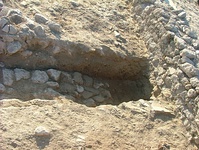
We did not have enough time to work adequately with the Byzantine strata. We dug only a few baskets dated in Byzantine period and therefore it is too soon to form a final opinion about the Byzantine activities at the Nezi area. However, it appears that a substantial grey, ashy layer (at least 6 meters in diameter) of Early or Middle Byzantine material will be exposed in 2008 which could very well represent some sort of industrial area (heavy burning) and would explain the large number of nails and iron lumps which were being excavated in this area this season. Nevertheless, on the basis of the evidence so far there was some activity in the Byzantine era in the southernmost part of the excavation area (1001.00N – ca 1006.00N) between ca 266.5 E and 274.00 E (B149, B161, B207, B215, B219, B 225, and 226). It is difficult to interpret B149 and B161 because they seem to extend further to the south of the limits of the excavation, and need to be evaluated in following sessions. B226, a small oval depression seems to be directly above the substantial grey ashy layer which will be exposed in the 2008 excavation season which will most likely date to the Early (610-802 AD) or Middle Byzantine (802-1058 AD) periods. B219, which is part of the fill of the foundation trench for the N-S wall at 269E, though small and incomplete, probably dates the construction of the N-S wall at 269E in the Middle Byzantine period on the basis of the pottery evidence. This wall was exposed in the previous sessions with B129 and B131 and was considered Frankish due to a coin of W. Villehardouin that was discovered in the fill covering the wall (B129). The presence of this coin can be explained by the use of this earlier wall by the Franks. During the Late Byzantine period (1059-1210 AD) a small part of this wall that maybe included a threshold, was robbed (B207, B215).
In addition, this N-S wall continued and was connected to an apsidal structure (that may have been added later based on limited exposure of the construction features) in the north (at 1008.60 N). We excavated both the wall of this structure and the area within it. While layers directly above the apse dated to the Late Byzantine or Byzantine NPD (B 176, 179, 213, 214), the construction of the apse clearly dates to the Middle Byzantine (B 206, 216, 217, and 222). The upper layer of soil within the apse dated to the Frankish period (B 204), but the lower levels varied from Frankish to Middle Byzantine (B 208 and 209). I suspect the reason for this is twofold; first, the lower levels of the interior of the building (I hesitate to call them floors since they were not level nor was there a deposit of material on them) are truly Byzantine and secondly, the area within the apse was partially excavated before wall itself which could have contaminated some of the material inside the structure.
Layers (B 218, 220, and 221) from the western edge of the apse and the western N-S wall (running along 266.00 E) of this building were dated to the Frankish period and will be dealt with in that section.
FRANKISH (1210-1458 AD)
A significant amount of our work was dedicated in the area between N-S wall at 266E (revealed with B 65, B115, B117, B131, B137, and B139) and N-S wall at 269E (revealed with B129 and B138), and in the area West of the N-S wall at 266E.
Courses of the western wall (running along 266.00 E) of this building were exposed in the north beyond the E-W crosswall (1006.00 to 1007.00 N) (B 218 and 220). Moreover, it seems that the crosswall extended further to the west and under the western balk of the excavation (B 221) and may have been the northernmost point of the original structure. However, the construction of the apse dates to the Byzantine period while most of the two N-S walls were exposed in Frankish levels. Thus we are excavating a lower, earlier level of the apse (giving it an earlier date), it may be part of an earlier building onto which the later Frankish building levels were set, or it may simply be explained by the fact that the ground slopes downward from south to north.
Regarding the area between the N-S wall at 269E and the N-S wall at 266E, it became evident that at least in the Frankish period, the area was used as a room and that it was covered by a roof. As stated above, the N-S wall at 269E must have been constructed in Middle Byzantine period (802-1058 AD). There is no evidence yet about the use of the room in the Byzantine period (excluding the apse area which may be a separate structure), because we did not excavate below the Frankish strata in this area. This wall continued to be used by the Frankish population as the east wall of a roofed room. The west wall of the room was N-S wall at 266E. The roof of the room suffered probably multiple destructions around the middle of the 13th century AD (B184, B210). We were able to trace the red floor of the room below the destruction in some areas of the room.
After the destruction of the room (B184, cut = B 191) a pit or well was created in the central West area of the room. This pit/well was used as a rubbish area for bones, tiles, stones etc. The digging of the pit/well was not completed in this session and its date is not secure (Frankish or Ottoman).
It is very possible that the area west of the N-S wall at 266E and its threshold is also a room, because with B196 we discovered part of a wall and its robbing trench that runs in the N-S direction and is almost parallel to N-S wall at 266E. This wall stands immediately to the east of the western limit of the excavation at 263E. The hypothesis that the area between the two walls is a room is supported by the discovery of a small area of red soil, possibly a floor immediately to the west of the threshold of N-S wall at 266E. For definite conclusions about the activity in this area we have to extend the excavation area further to the west and also to study carefully the area to the north, where B141 and B142 were done.
A small partial roof destruction limited to the southeast of the threshold of N-S wall at 266E and dated to the first half of the 13th century AD can either belong to a roof of the area west of N-S wall at 266E, or to a roof of the room east of N-S wall earlier that that of B184. This small part of the roof could have slipped and fallen from the roof of a room west of N-S wall at 266E in the area east of N-S wall at 266 E, then unroofed. It could also have fallen vertically down from a roof covering a room east of N-S wall at 266E.
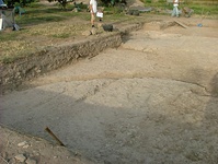
East and north of the structure discussed extensive layers of fill were excavated exposing very few features. These baskets of fill extended from 265.00 to 279.00 E and 1001.00 to 1013.82 N (B 172, 181, 200, 202, and 212). In the southeastern corner of the excavation (274.00 to 279.00 E and 1002.00 to 1006.00 N) there were a number of layers that were clearly clay surfaces (B 165, 167, 175, and 185). These layers consisted of a hard, packed clay on whose surface many finds laid. Earlier in the season, channels (B 68) were exposed running across this space and it was suggested that these may have been irrigation channels. However, it is now believed that it was not garden fill deposited in this area. In addition, a small pit (B 183 and cut 186) was cut into these clay surfaces. The material of this pit was dated to the second half of the 13th century, the same date as the clay surfaces. Moreover, the relatively straight edges of the north (discussed below) and west edges of these surfaces suggest that they may have been at the edge of a building, if not necessarily inside.
In addition, a possible robbing trench was cut into the northern edge of these clay surfaces (B 173 and cut 182). With the flat, clay surfaces jutting against this trench’s southern edge, it very well may represent the robbing of an E-W wall. This trench (B 182) is also cut by another trench (B 111) which runs N-S. Further consideration and excavation will be necessary to understand this area.
Even further to the north of this trench, we removed a martyr between a pit-like area (B 104) and a small wall (B 170). We then removed the small cobble wall (B 199), dated to the second half of the 13th century, which was collapsing off the north edge of the Nezi excavations.
Throughout the central area of the excavations (269.00 to 274.00 E and 1001.00 to 1011 N) we removed a thick layer of soil that can be best described as silty (B 188, 223, and 227). This soil contained little pottery (in comparison to other areas of fill here) and many bones. Since there is a depression in the Nezi field at this point, it is reasonable to suppose that this soil was washed into place by rain or flooding. Below it we were exposing a black/grey ashy layer which will be excavated at the beginning of the 2008 excavation season.
Above this silty soil, we removed one small clay patch (B 224) that jutted against the N-S wall which runs along 269.00 N. In addition, two pits were cut through these levels. The first (B 151 and cut 187) (at 271.00 to 272.00 E and 1002.00 to 1002.50 N) was exposed by B 140. The second (cut B 193) was a substantial pit (270.00 to 271.80 E and 1007.00 to 1009.30 N) exposed by B 145 (the layer directly above B 188). This pit (B 147, 148, 150, 153, 159, 160, and 163 = martyr) was dumped with fill that varied substantially in date although the latest material was dated to the Frankish period. We stopped digging at B 160 after determining that it has cuttings into the bedrock for a well and that to continue any deeper would be dangerous and logistically difficult at present.
EARLY MODERN (1831-1949)
This session’s survey did not add much to the evidence we had from the previous sessions about the Early Modern activities in the Nezi field (a property boundary wall, an ash pit, agricultural activity). In the Early Modern period part of N-S wall at 264E, which was revealed in B52 and B54, was robbed, as the pottery found in the robbing trench of the wall confirms (B 197, B 198, B 201). In addition, a layer of soil (B 180) over a portion of this wall, which was left at higher level and not robbed as parts both south and north of it, suggesting it may be a different wall crossing this one) also dated to the early Modern period.
CONCLUSIONS
We have begun to uncover layers of Byzantine material in the Nezi excavations. It appears that the lower levels of the walls and the interior fill of the only building exposed all belong to this period. Moreover, the final days of excavation exposed a grey, ashy layer over a large area of the field which will almost certainly date to the Byzantine period once it is excavated next season.
The majority of the excavations carried out during this session were securely dated to Frankish contexts. During this period we see a space being actively used in the southwest corner of the excavations, which may or may not be an interior room but further investigation will be required to determine this. Also, human activity is visible within the structure. At some point in the 13th century there are multiple destructions, after which a large pit is cut into the floor of the interior of the building.
Outside of this building, one finds several hard, clay surfaces in the southeastern corner of Nezi field. These surfaces exposed finds laying flat upon them. The trench cut to the north of them and the fact that the western edge of them is relatively straight suggests that they may indeed be floors of some sort. In addition, the whole Nezi area north and east of the building seems to have been primarily covered in layers of fill under which a large silty layer had washed through the area. This silty area seems to be dividing the Frankish and Byzantine deposits suggesting a possible period in which it was not used. The numbers of iron nails and large iron lumps found throughout this area and the large ashy deposit made visible by the removal of this silty soil all suggest, in my opinion, that we are coming onto an exterior space used heavily for industrial purposes.
Several additional cuts (which may represent robbing trenches for walls) and deep pits make up the only other features in this area. The large number of pits also suggests that this was an outdoor area.
Finally, the only significant evidence for the early Modern period in this session’s excavation include a number of layers which were removed from a robbed out wall that was exposed in the northwestern corner of the excavation. I suspect that the wall itself dates to the Frankish period and it was robbed out during the Early Modern period.
|