Corinth Report: Nezi Field 2009 by Martin Wells, Katie Rask (2009-06-17 to 2009-06-18) | Collection: | | Corinth | | Type: | | Report | | Name: | | Nezi Field 2009 by Martin Wells, Katie Rask (2009-06-17 to 2009-06-18) | | Title: | | 2009 Excavation summary | | Context: | | Nezi Field, context 6614 | | | | Nezi Field, context 6541 | | | | Nezi Field, context 6556 | | | | Nezi Field, context 6636 | | | | Nezi Field, context 6593 | | | | Nezi Field, context 6662 | | | | Nezi Field, context 6569 | | | | Nezi Field, context 6629 | | | | Nezi Field, context 6596 | | | | Nezi Field, context 6553 | | | | Nezi Field, context 6659 | | | | Nezi Field, context 6618 | | | | Nezi Field, context 6580 | | | | Nezi Field, context 6551 | | | | Nezi Field, context 6447 | | | | Nezi Field, context 6455 | | | | Nezi Field, context 6620 | | | | Nezi Field, context 6595 | | | | Nezi Field, context 6581 | | | | Nezi Field, context 6603 | | | | Nezi Field, context 6438 | | | | Nezi Field, context 6627 | | | | Nezi Field, context 6617 | | | | Nezi Field, context 6515 | | | | Nezi Field, context 6592 | | | | Nezi Field, context 6626 | | | | Nezi Field, context 6542 | | | | Nezi Field, context 6535 | | | | Nezi Field, context 6602 | | | | Nezi Field, context 6623 | | | | Nezi Field, context 6615 | | | | Nezi Field, context 6524 | | | | Nezi Field, context 6632 | | | | Nezi Field, context 6497 | | | | Nezi Field, context 6533 | | | | Nezi Field, context 6625 | | | | Nezi Field, context 6622 | | | | Nezi Field, context 6598 | | | | Nezi Field, context 6570 | | | | Nezi Field, context 6474 | | | | Nezi Field, context 6563 | | | | Nezi Field, context 6518 | | | | Nezi Field, context 6492 | | | | Nezi Field, context 6661 | | | | Nezi Field, context 6565 | | | | Nezi Field, context 6562 | | | | Nezi Field, context 6601 | | | | Nezi Field, context 6591 | | | | Nezi Field, context 6486 | | | | Nezi Field, context 6630 | | | | Nezi Field, context 6469 | | | | Nezi Field, context 6605 | | | | Nezi Field, context 6644 | | | | Nezi Field, context 6648 | | | | Nezi Field, context 6610 | | | | Nezi Field, context 6564 | | | | Nezi Field, context 6483 | | | | Nezi Field, context 6557 | | | | Nezi Field, context 6599 | | | | Nezi Field, context 6545 | | | | Nezi Field, context 6546 | | | | Nezi Field, context 6640 | | | | Nezi Field, context 6635 | | | | Nezi Field, context 6547 | | | | Nezi Field, context 6678 | | | | Nezi Field, context 6652 | | | | Nezi Field, context 6597 | | Area: | | Nezi Field | | Site: | | Corinth | | City: | | Ancient Corinth | | Country: | | Greece | | References: | | Baskets (67)
|
Katie Rask, Marty Wells
ASCSA Corinth Excavations
End of Season Report
Blue Team
North of Nezi
The following is a summary of the excavations carried out in the area north of Nezi field during the 2009 season. Three teams worked in this area over the three sessions. In the first session, 29 March – 24 April, Ryan Boehm and Joanna Potenza were supervisors. They focused on four areas: the westernmost room bounded by walls 5631 and W54; the room bounded by walls 10080, 10076, 10077, 10087 and W55, both east of the central courtyard of a Byzantine house (E: 274.70 – 281.69; N: 1026.30 – 1032.55 including the southern walls); the room bounded by walls 10081, 10082, 10083, 10086, and 10079, an addition built outside of the eastern edge of the house (E: 282.15 – 284.95; N: 1027.15 – 1030.25); and a series of roads running N-S east of this addition (E: 285.4 – 286.65; N: 1029.30 – 1032.40). In the second session, 27 April - 22 May, Katie Rask, Dreya Mihaloew and Martin Wells were supervisors. They focused on the room between walls W55 on the north (N 1034.30), 6267 on the south (N 1026.97), 10086 on the east (E 282.15) and W54 on the west (E 273.95). Rask and Wells continued supervising in the same room during the third session, 25 May -12 June. This report provides a summary and interpretation based on the season as a whole.
Our objective this season was to expose the 11th century levels for the purpose of opening up this house for public display. The director was Guy Sanders, the field director Alicia Carter, the pickman Thanasis Notis, the shovelman Tasos Kakouros and the barrowman Vasilis Kollias. The dry sieve was operated primarily by Sula Anastasopoulou, Kollias, Rask, Mihaloew, and Wells.
Previous Activity: 1961
Under the directorship of Henry Robinson, Section F of the Byzantine house was explored by William Berg III in the spring of 1961. At some time after the completion of excavation (either in 1961 or later in the 60s when excavation in the Agora Southwest was closed) portions of the room were back-filled, while other areas were left exposed. Following his work, no archaeological activity was undertaken in the area except for a cleaning in 2007, when it was weeded, covered with plastic, and back-filled.
In the room which was the focus of our excavation throughout all three 2009 sessions, Berg had exposed walls W54, W55, 10080, 10083, 10086, 10088,10094, 5631, an E-W drain (5938), and well 6288. Additionally, he sunk trenches in all four corners of the room; these may have been further excavated while searching for the Roman road. The combination of back-filled and exposed areas, as well as the recording practices in the 1960s, had an effect on our ability to interpret the pre-60s stratigraphy. For this reason, extensive study of Berg’s photographs and excavation notebooks was undertaken in order to determine how his activity impacted the space of the room prior to our renewed excavations. A detailed discussion of the four corner trenches is attached as Appendix B of this report. More general references to Berg’s results are included in the pertinent discussions below.
Frankish (1210-1458)
The Frankish period seems to have witnessed a great deal of activity and renovation in our space, with the most active period being the second half of the 13th century. Of the features dated to this period, most can be placed either in the third quarter or in the later part of the century. During this time span, the form and use of the room changed on several occasions. A wide variety of new or changed elements in the room indicate this, including the addition of rooms, walls, a drain, thresholds, floors and fills.
Well 6288
One of the main actions pointing to the changing use of space was the closing of well 6288, which was filled sometime in the third quarter of the 13th century. Because the excavation and processing of the well was a significant part of the season’s work, and because its contents will be the subject of considerable further study, in what follows we will provide a detailed description of our results from the well’s excavation. Afterwards, the discussion will return to the other 13th century activity.
The well had originally been examined on May 13, 1961 (NB 229, p. 109) and designated Well OA-107 (coordinate designation) at that time. Berg excavated it for less than a meter and recorded no finds. He postulated that it belonged to the Turkish period and did not excavate deeper because of its narrowness. Our own investigation began by removing 0.45 m of backfill and debris before excavation. Initially we attempted to determine context changes based on differences in soil composition and inclusions; however, after approximately 2.0 meters of excavation, the Director advised that we should change contexts approximately every 0.30 m. This was our primary method of excavation, but we also changed contexts when stratigraphically necessary. All the material from the well was dry sieved with 7mm screens and 3mm starting with context 6420. Water flotation samples (15 L) were also collected from every context. 32 contexts were removed in total, but the bottom of the well was not reached nor was the structure (6288) itself excavated.
The material removed from the well indicates three discernible dumping actions dating to the Frankish period, between 1270-1290 C.E. The character of these deposits, however, suggests that the well was filled over a short time. The latest dumping layer (6286, 6291, 6297, 6360, 6361, 6365, 6368) fills the top 2.75 meters of the well. The contexts comprising the layer included a large amount of pottery, bone material, and various smaller finds such as iron nails, glass, and bronze objects. The proceeding (and underlying) dumping action revealed a dramatic decrease in the number of inclusions, with a very small amount of pottery and bone, and a significant increase in the ash and charcoal content of the soil (6369, 6371, 6374, 6378, 6383, 6386). Below and proceeding the ash deposit was another dumping action (6394, 6400, 6405, 6412, 6416, 6420, 6430, 6438, 6447); this deposit was characterized by soil with a high clay content and very little ash, extremely large amounts of pottery (with a high proportion of fine ware) and a very large amount of animal bone.
At a depth of 11.70 m (elev. 73.40 m) we reached the water table (context 6518). The pottery and bones were still present at their normal high amounts so we continued excavating for another 37 cm, to a depth of 11.88 (elev. 73.03 m), at which point we felt that it was unsafe to continue. The last context was 6524.
The latest pottery found in the well dates to a twenty-year span (1270-1290), but the three dumping actions apparent amongst the contexts are not chronologically separate, despite their stratigraphic relationships. In addition, the presence of complete vessels suggests primary deposition, but the occurrence of incomplete and fragmentary body sherds also indicates the secondary deposition of pottery. This interpretation is supported by the bone material. The excellent preservation of delicate and small bones (e.g., of fish, cats, birds), as well of the articulation of some bones, can be indicative of primary deposition; on the other hand, a large amount of weathered and fragmentary bones suggests the secondary deposition of animal remains.
Personal communication with Thanos Webb, the excavation’s zooarchaeologist, emphasized the distinct nature of the bone material that had been removed from the well. The preservation was very good, with little weathering and the presence of smaller and more fragile elements. There was an abundance of different anatomical elements, representing parts from the entire skeleton. The surface modification of the bones was also distinctive, with the butchery marks on multiple elements being far more extensive than that on bones from areas outside the well. Finally, the species representation from the well was also conspicuous, ranging from common domesticates to large birds and fish, and with an age distribution ranging from fetal to mature. Additionally, large amounts of microfaunal remains and fish scales were collected from the dry sieve. These have yet to be analyzed.
In addition to the pottery and bones, we recovered small finds of both a utilitarian and luxury nature. These included stone and bone tools, iron nails, bronze lumps, worked bone artifacts, spindle hooks and whorls, and glass. Twenty-seven coins were recovered. Nearly half of these were illegible, and of those which we could date, most were Late Byzantine and Frankish. None need to be later than the 3rd quarter of the 13th century, chronology in agreement with our pottery. A complete list of the contexts and coin dates can be found in Appendix A of this summary.
The well structure itself was not excavated, so our only evidence for the construction date of the well comes from our limited excavation of the fill (6536) inside the construction cut (6535). The pottery from this context dated to the 10th/11th centuries. Given the large amount of dumped 10/11th century fill in other parts of the room which stratigraphically date to the 12th century (see below), the small sample provided by the construction trench cannot assuredly date the well’s first use phase. Still, if one considers the dating of the contexts surrounding the well (see below), we can speculate that well was in use from the 10th/11th centuries until it was closed at the third quarter of the 13th century.
Other 13th century activity
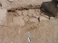
The character of the other 13th century actions in the room also reflects an alteration of the space. In the 3rd quarter of the century, sometime around the closing of the well, a long drain (5938) was laid running E-W and extending eastward out of the room. In order to extend the drain completely to the road, a small portion of wall 10083 had to be removed. The pebble/cement floor associated with the drain (5934) suggests that the room continued to act as an outdoor space, as it had previously in the 12th century. Two piers (5957, 10077) set up at the room’s south east boundary and a threshold (5919) placed between served to monumentalize the passageway between our room and the one to the south. At the same time, another pier (6148) was placed to the north on an axis with the eastern pier; it was placed against the west end of wall 10087 and can be dated by the fill which it cuts to the south (6141). Together the three piers must have served a supporting function for an upper level or arch. By the end of the century the threshold had been walled up and two connecting N-S walls (10094, 10080) were added at the western pier to slice the entire room in half, separating the well and staircase from the room’s eastern portion.
In order to build wall 10094 it seems that digging activity of some sort was undertaken, probably to clear the space for construction. We have not settled on a firm interpretation of the activity here, however. Originally we believed we had found a robbing trench for another pier foundation (6273), located on an axis with the other three. Further excavation revealed that the pier foundation cut was part of a longer N-S cut (6254/5, 6240, 6565, 6569) truncated by Berg’s corner trench (6570). The lower portion of the cut contains fill with 12th century dates (6274, 6581); the robbing of the upper portion, evidently begun at the southern end, can be associated with the 13th century (6225, 6240). Conclusions about the history of activity in this region are tenuous, but may include, for example: a) an earlier wall was robbed out in the 12th century, another placed in the same cut at a higher layer, and that robbed out in the 13th century, b) a wall was removed at some point and a pier foundation was sunk in its place to coincide with the other three, then removed for 10094.
The removal of other features was also necessary to reshape the space. For example, an E-W wall (6052) ending at 10086 must have been removed to accommodate the threshold placed just at its south. The robbing trench left behind by the wall’s removal was later cut by pit 5935. This pit may have been dug to remove a large pithos, evidenced at the south end of the pit by its deeper circular depression, perhaps located at the corner of walls 6052 and 6424 and therefore outside the boundary of our room and adjacent to its south (see Appendix B).
12th century
Whereas the 13th century activity in the room involved the movement and construction of numerous built features, at present it seems that the 12th century activity, while extensive, cannot be linked to any extant architectural elements within the room. Instead, the 12th century activity is marked by a series of leveling and dumping activities that can be situated in two general time periods, the early 12th century and the second half of the century.
The most dramatic of these is a deep layer of multiple dumping actions in the southern part of the room. In the early part of the century, an extensive cut was made that truncated a grey clay floor in the west and extended to the eastern edge of the space. The cut was filled with many deposits of a mixed nature; in particular, several lenses of fill contained pottery of multiple periods and included large dumps of roof tiles (e.g., 6191: 21.4kg, 6186: 24.9kg). The mixed nature of the pottery deposit suggests that it was removed from another context before deposition in the room. In fact, the majority of the lenses were dated by pottery to the 10th/11th century (6629, 6626, 6622, 6194, 6196, 6198, 6225), while the dumping activity can be securely dated to the 12th century by the lowest fill level (6662).
Redeposited 10th/11th century material was also used to make up the matrix of a series of pebble floors in the room’s NE corner (6593, 6592, 6591). The floors were truncated on all sides, but can be dated by a deep fill beneath (6605) containing early 12th century pottery and very well-preserved bones (with nearly complete and fragile examples, suggesting primary deposition). Because the patchy pebble floors exhibited wear patterns compatible with the pooling of water, during the early part of the century we suspect the room to have been an outdoor space.
The evidence for architectural adaption in the courtyard during the twelfth century is scanty. A feature running N-S east of the well may have been removed (see above). An E-W wall (6426) may also have been removed, since a series of robbing trenches were found (6042, 6046), but since the wall has not been fully excavated, we cannot be certain of its chronology.
10th/11th century
Our understanding of the 10th and 11th century phases of the room is currently incomplete, since our efforts have focused primarily on removing 12th and 13th century remains. As mentioned, many of the dumped fills that we have encountered were dated by pottery to the 10th/11th century, but belong stratigraphically to later periods. We also have 10th/11th century dates for the patchy floors and some of the fills below them in the NE part of the room, but these are stratigraphically dated to the 12th century as well.
A large drain was located outside the room, east of wall 10086 under the later additions to the Byzantine house, curving from the southwest (10079) north and west to 10083. Situated under what was once the wider Medieval road, the drain was covered by squared limestone slabs probably removed from the nearby Roman road. The fill and surface above the drain contained pottery of the 10th and 11th century, but as the cut and fill excavated seems to have been related to a later repair, we are not able to establish a firm chronology for the drain’s construction. Moreover, given the stratigraphically later 10th/11th century fills common in the room, the date should probably remain speculative for the time being.
Otherwise, we have no structures that can be assuredly dated to the 10th and 11th centuries. In the western portion of the room, a grey clay floor has been uncovered through which the well was cut. The fill inside the well construction cut was dated to the 10th/11th century, as were the fills above this floor and the cut. However, as stated above, given the limited excavation of the construction cut, the unexcavated well structure, and the disturbed nature of this part of the room, we only tentatively date the well construction to this period.
Suggestions for further excavation
One area of particular interest for future research is the architectural phasing of the area. This is especially relevant since the room appears to have served as a courtyard in the 12th century and its boundaries seem to have shifted on several occasions. For this reason, it might be worth considering the room’s relationship to the other external courtyards. It is also a possibility that the space’s form and function changed as the larger building was broken into smaller units.
In keeping with the premises of open-area excavation, we have endeavored to extract all 13th century and later levels from the room (the exception being the unexcavated well deposits below the water table). Nearly all 12th century levels have been removed. We recommend that the following steps be taken to clear any remaining 12th century evidence before proceeding to the earlier Byzantine periods.
1)Any remaining fill from the unfinished portion of 6662 should be removed, particularly the dumped fill in the area north of 5935 and west of 6556/7. The relationship between that fill and the eastern area of the room should be further clarified (particularly in the region of wall 10086 and cut 5935).
2)If permission to remove wall 6426 has been acquired, then it should be taken out and the area beneath it examined in more detail. It may have been partly robbed out in the 12th century, but its construction date has not yet been identified.
3)The staircase (6324, 6325, 6333) can be further examined by excavating the space between the lower and upper steps. It is probable that the staircase was added after the well was closed, since it partly overlies the well packing, but a more precise date for its construction would be helpful.
4)The triangular area 6648 laid against walls 10086 and 10087 should be excavated. We believed that it may have been outside cut 6678, but its stratigraphic make-up should be determined more precisely, since its last level to be removed was part of the larger context 6648.
5)The grey floor south of the well should be examined in an effort to understand its use phases, the date and function of wall 6422 and the collection of rocks visible in the 1960s sondage section.
6)The uneven fills in the northeast part of the room should be removed to explore their make-up and to determine if they actually date to the 10th/11th century or if they are part of the 12th century leveling action. Their removal will also allow the investigation of the floors beneath them that had been cut by 6678.
7) If the lower levels of the room are reached, three particular questions that have been created by earlier excavation might be addressed:
A. What were the circumstances of the skeleton’s deposition in the NE corner? (See Appendix B) Why was the body haphazardly laid out and why was its skull covered by 10087?
B. What is identification of the line of stones at the bottom of the N-S cut (6273)? The soil south of the stones seemed to be full of hollows. Might it be an earlier well, as Thanasis has suggested, or another type of open space?
C. A N-S wall was uncovered by Berg in the NW trench (6570) and re-found in 2009. It appears to be a finely constructed wall abutting the earlier phase of W55, forming a precise corner. How does this change the plan of the building and the understanding of the long entrance alley to the north? Does the wall have any relation to the Byzantine house at all or is it entirely pre-Medieval?
Appendix A: Well coin dates
Context Coin # and date
6286
#123 Corinth medieval 1245-1250
6291
6297
6360
6361
6365
6368
6369
6371
6374
6378
6383
6386
6394
6400
6405
#99 medieval illeg.
#102 Manuel I 1167-1183
6412
#103 medieval illeg. 1092-1399
#104 Villehardouin 1250-1260
#107 illeg.
6416
#114 illeg. 1092-1261
#115 Roman Imperial
6420
6430
#119 Manuel I 1143-1180
#120 medieval illeg. 1092-1261
#121 illeg 324-599
#122 Greek – Corinth 400-146 BC
6438
6447
#126 illeg. 1092-1261
#127 illeg. 1092-1399
#128 illeg. 1250-1330
#161 illeg.
6455
6469
#137 Alexius I 1085-1092
#139 illeg.
#140 illeg. 1204-1261
6474
#142 Manuel 1 1143-1180
6483
#149 illeg.
6486
#146 medieval illeg.
#150 illeg.
#151 Byzantine illeg.
6492
6497
#153 medieval
#154 Byzantine
#155 Byzantine
6515
6518
6524
Appendix B
NB = Berg’s notebook, #229.
PV = Photograph volume 18, 1960 II
Berg included a number of plans of Section F, which he updated throughout the season as new information came to light. His drawings have been useful for reconstructing his activity at the time, although his plans do often focus on architecture to the expense of other important features (e.g., he never depicts well 6288). His adherence to the overall grid is often inexact. It appears that his elevations, in contrast, are quite accurate; they can be tested both at the 13th century drain (5938) and at the bottom of 6173.
Two of the corner trenches were cleaned during 2009’s Session1 by Potenza and Boehm, that in the southwest (5935) and southeast (6223).
5935: This area was originally excavated by Berg on June 10th, 1961 (NB: 192, 195). He mentions working in the area between his walls #33 (10080/10094), #27 (10086/10087), and #23 (10076/10077). Although Berg does not describe the excavation of a deep pit or bothros, a figure-eight-shaped pit is visible in the end-of-excavation photographs (PV: p 32, 61-24-4); it was cleaned, defined and recorded by Potenza and Boehm as cut 5935. Berg’s silence on the issue of the pit may be due to the fact that its excavation was done on the last day of the season, with work ending at noon. The material was saved as Lot 662. Because the stratigraphy was so disturbed by both Berg’s excavation and by later weathering, 5935’s original digging cannot be placed securely in the room’s sequence of events. It clearly occurred after the filling of 6042/6046 (RT for 6052), which it truncates, but otherwise we can not exactly place it on the Harris Matrix and have thus left it floating.
6623: Berg refers to this area, excavated on June 6th, 1961 (NB: p. 182), as the space between his walls #34 (W54), #33 (10080/10094), and #25. No photographs of the specific area were taken, but it is depicted in the post-season views found in PV. The photos indicate that in this area, Berg excavated everything to the level of the top of the well, with two specific features down to a lower level. The first is the sondage taken at the corners of W54 and 6267/5361; it was cleaned by Potenza and Boehm but not given a number. According to the photos, Berg’s excavation of the sondage revealed the northern face of 6267/5361, the wall located about a meter or so north of Berg's Wall #25 and the southwest boundary of our own trench. Berg did not include wall 6267/5361 on his plans, but it does seem to have been drawn on the 2009 Nezi field plan. The pit that he excavated at this time has a large number of jumbled rocks on its east face (under wall 6422). It is unclear if 6422 was excavated by Berg, but on his final plan (p. 188) he draws a small structure that jogs east and then south from W54 in a similar way to how we originally interpreted 6422; this may be a reference to his sondage and the jumbled rocks therein, or to 6422. Also likely, however, is that the structure drawn by Berg refers to a pile of larger rocks possibly visible north of the sondage and south of the staircase in photo 61-26-5 (p35); again, this interpretation is based on a general photograph of the area as there was no detailed description in Berg’s notebook.
The second delineated feature visible in the photographs is a circular pit to the east of the sondage and up against Berg's wall #33 (our 10080). This is probably what Berg refers to on p. 182 as a circular pit just west of his wall #33 and north of his wall #25. He indicates that the pit had a plastered southern face and was filled with fine white ash. The pottery was saved as Lot 683. He excavated the pit to an elevation of 84.16m. Our season’s closing elevation was 84.18m, a difference of only .02m, and was taken approximately under the pit’s location as visible in the photographs (at the bottom of 6662).
The placement of Berg’s corner sondage had some bearing in our interpretation of contexts 6620 and 6338. 6620 was made of an extremely soft and ashy fill that was exposed by Potenza and Boehm’s cleaning at the beginning of the season, and was partly removed by 6338 and further sweeping. Its softness and the its straight northern boundary suggested that it might be back-fill. In the 1961 photographs, the sondage does not appear to be located so far north, leaving the possibility that the softness of the soil was a result of exposure to the elements, foot traffic and other 2009 excavation activity. Nevertheless, it is still possible that the area was excavated further after the 1961 end-of-season photos were taken and that 6620 was composed of re-deposited earth - if so, the excavation activity must have been completed after Berg's 1961 efforts. See PV: p. 34, 61-26-4; p. 35, 61-27-1, 61-27-2, 61-26-5.
The two corners in the northwest (6570) and northeast (6173) were cleaned by Rask and Wells in 2009’s Session 2 and 3:
6173: This northeast corner was originally excavated by Berg on June 9th, 1961 (NB: p. 192) and continued on June 10th, the final day of the season. Berg stopped digging at a hard surface found at 84.20m, at which point the wall foundation trenches for W55 (#34) and 10086 (#27) were visible. At this level he also uncovered a skeleton lying in a disheveled E-W position with its head beneath10087 (PV: p. 25: 61-15-3). Berg makes clear in his notebook that the area would not be excavated any further beyond their stopping point at 84.20m, the level of the skeleton. Our excavation has shown, however, that some time later digging must have taken place, as an irregular pit cuts through the hard surface at which Berg stopped (our measurement shows the disturbed hard surface to be 84.10m, slightly lower than Berg’s stopping point at 84.20m). The later digging cut through the wall foundation trench noted by Berg and continued to a presently undetermined depth. It is unclear when this digging happened and by whom it was undertaken.
6570: The northwest area was originally exposed on May 26, 1961 (PV: p. 35, 61-27-7). It began as a soft fill that was excavated to a hard level at 84.06m. He speculated that the soft fill was W54/55's foundation trench (p.151). The hard soil was then removed from W54 eastward towards Berg's wall #33 (10094/10080). Berg originally drew #33 as extending from our room northward beyond W55 (plan, p. 101); if the wall truly extended that far north than its northern portion must have been removed by Berg. Unfortunately, the end-of-excavation photographs do not clarify the matter, although they do seem to indicate that Berg excavated a N-S trench possibly crossing over W55 that terminated in a large round pit to the north (PV: p. 36, 61-27-3). It is not possible to say much more from the photographs nor to determine if that cut/pit had any relation to the activity in our room. Moreover, no mention is made in Berg's notebook of the wall we designate 10095 and which seems to have been the easternmost point of their trench here. It is drawn on two of his plans, although it seems to be indicated in the wrong spot on his last plan (p. 157 and 188). The area of 6570 was excavated down “to levels of obviously Roman or Classical date" (p. 167) and was presumably closed on May 30th, 1961. The pottery from Berg's exploration was saved as Lots 672, 673, 675.
Our interpretation of the N-S cut 6273 was affected by 6570, since Berg’s excavations truncated the cut. It is also unclear if Berg partially exposed the line of rocks at the preserved northern end of 6273.
|