Corinth Report: Nezi Field 2009 by Stella Diakou and Cavan Concannon (2009-03-30 to 2009-04-16) | Collection: | | Corinth | | Type: | | Report | | Name: | | Nezi Field 2009 by Stella Diakou and Cavan Concannon (2009-03-30 to 2009-04-16) | | Title: | | First Session Summary | | Context: | | Nezi Field, context 470 | | | | Nezi Field, context 441 | | | | Nezi Field, context 464 | | | | Nezi Field, context 445 | | | | Nezi Field, context 468 | | | | Nezi Field, context 437 | | | | Nezi Field, context 455 | | | | Nezi Field, context 457 | | | | Nezi Field, context 446 | | | | Nezi Field, context 479 | | | | Nezi Field, context 435 | | | | Nezi Field, context 461 | | | | Nezi Field, context 458 | | | | Nezi Field, context 452 | | | | Nezi Field, context 434 | | | | Nezi Field, context 459 | | | | Nezi Field, context 436 | | | | Nezi Field, context 477 | | | | Nezi Field, context 451 | | | | Nezi Field, context 471 | | | | Nezi Field, context 462 | | | | Nezi Field, context 449 | | | | Nezi Field, context 438 | | | | Nezi Field, context 478 | | | | Nezi Field, context 475 | | | | Nezi Field, context 440 | | | | Nezi Field, context 465 | | | | Nezi Field, context 473 | | | | Nezi Field, context 443 | | | | Nezi Field, context 474 | | | | Nezi Field, context 442 | | | | Nezi Field, context 453 | | | | Nezi Field, context 460 | | | | Nezi Field, context 463 | | | | Nezi Field, context 467 | | | | Nezi Field, context 447 | | | | Nezi Field, context 456 | | | | Nezi Field, context 466 | | | | Nezi Field, context 480 | | | | Nezi Field, context 454 | | | | Nezi Field, context 469 | | | | Nezi Field, context 481 | | | | Nezi Field, context 439 | | | | Nezi Field, context 448 | | | | Nezi Field, context 476 | | | | Nezi Field, context 450 | | | | Nezi Field, context 444 | | | | Nezi Field, context 472 | | Area: | | Nezi Field | | Site: | | Corinth | | City: | | Ancient Corinth | | Country: | | Greece | | References: | | Baskets (48)
|
We, Stella Diakou and Cavan Concannon, from March 30 to April 16th, 2009, began excavation in the northwest area of Nezi Field. The corners of our excavation area are as follows: SW corner - E255.41 and N 996.48, NW corner - E255.40 and N1014.89, NE corner - E263.89 and N1013.85, and SE corner - E263.38 and N 1006.08. We worked under the supervision of Guy Sanders, Alicia Carter, James Herbst, and Ioulia Tzonou-Herbst. We excavated with Panos Stamatis (pick man), Stavros (barrel man), and Sotiris Raftopoulos (shovel man).
In 2008 a large context was defined but only partially removed with context 411. Our objective was to finish excavating this context (which we did with contexts 434, 436, 439, 440) and unite the stratigraphy of the northwest corner of the Nezi field. We sought to continue investigation of Turkish, Frankish, and Byzantine remains uncovered here, along with early modern activity that disturbed these earlier remains. The overall goal of the Nezi field excavations has been to show the relationship of this entire area to the area immediately to the north which was excavated in the 1960s under the the direction of H. S. Robinson.
Early Modern (1831-1949 CE)
Throughout our excavation area we excavated a number of agricultural deposits containing 18th and 19th century pottery, mixed with 13th and 14th c. material (contexts 434, 435, 439, 442, 443). The mixed nature of these deposits, coupled with the fact that they cover most of the area of excavations, suggest that this area was plowed and used for agricultural purposes during the early modern period. Added evidence for this conclusion is the removal of an early modern wall in the 2008 excavations, which served to mark the boundary between agricultural fields in the area.
Earlier than these agricultural deposits, but still during the early modern period, we have a number of dumped fills to the W of B54 which seem to be the result of intentional human action. This is indicated by the fact that the pottery in these deposits date from the 12th to 14th centuries, yet they are laid on a 19th century deposit (458). The mixed character of the deposits shows that they were probably dug out sometime in the 19th century and redeposited.
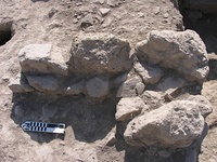
We excavated three deposits that we interpreted as dumped stones (447-449). They seem to have been intentionally laid down, perhaps from wall-robbing activity in the area. There is evidence in the area for the robbing of several walls (366, 332, 306, B54) but we cannot associate these piles with any particular wall-robbing activity. They may have also been placed here after other digging activity in the 19th century.
Another indication of human activity in the early modern period is an ash layer (454 and 455). This deposit was found sitting on the 19th century deposit (458) that underlay most of the area W of B54. It consisted of a layer of loose ash that was laid on a hard packed layer of limestone and ash. This may have been related to cement-making activities in the area. It has been suggested that ash and burnt limestone from a nearby kiln were thrown here and later contact with water hardened the lower layer (455).
The key to our dating of this area was a deposit (458) that was overlaid by several piles of stones and the deposits of 12th-14th century dumped fill. We realized early on that context 458 was running under much of the area W of the robbing trench (B54) running N-S on the E end of our area (at approximately E264) and so we carefully removed the deposits that overlaid it. Though we expected a Frankish or Late Byzantine date for context 458, pottery analysis determined that it contained 19th century materials, which forced us to change our understanding of this area. The extent of the deposit and the number of deposits that were dumped on it suggest that this may have been a usable outdoor surface in the 19th century.
In the course of our excavation of early modern deposits in the northeast part of our area (443, 458) we uncovered a floor which was constructed of hard packed red soil (not yet excavated), which had been partially revealed in 2008 with the removal of 411. This floor was cut at a later point by cut 272. Three stones forming a wall stub on the W side show a clear alignment with the red floor. There appear to be remains of a pit (not yet excavated) that cuts the red floor and there is also an ashy deposit which may be a hearth where it meets the robbing trench (B54) at the E limit of our area. The floor has not been excavated yet; therefore, we cannot assign to it a definite date. The 19th c. deposits (443, 458) that overlaid the floor can give us a terminus ante quem for its construction.
Frankish (1210-1458 CE)
The most significant evidence for Frankish activity is the robbing activity (cut 451) at the intersection of walls 366 and 332. The excavation of that area and the dating of the pottery from the deposits that filled the robbing trench (450, 453) showed that walls 366 and 332 were robbed sometime in the 13th-14th centuries. This area was specifically chosen because of the availability of good corner blocks from the walls. The excavation revealed that the walls were not fully robbed down to their foundations; instead we were able to find the continuation of walls underneath the bottom level of the robbing trench. The date of the robbing trench gives us a terminus ante quem for the construction of walls 366 and 322. Further excavation in this area is necessary in order to determine the relationship of this robbing trench with the N-S robbing trench (B54) and the existence and extent of the foundation trenches of these walls.
During the excavation of this Frankish robbing trench we uncovered a white ware jug which has been interpreted as a foundation deposit for wall 332. The jug was revealed in the scarp of the robbing trench with the removal of context 453, but it is more likely that the jug is associated with the fill of the foundation trench on the W side of wall 332. This foundation trench has not yet been excavated or revealed. We expect that the cut for the foundation trench will be revealed with the removal of the reddish floor surface W of wall 332.
The deposits (456, 465) that covered structures 477 and 478 (a possible partition wall at the corner of the N-S robbing trench [B54] and wall 366) and floors 480 and 481 may be slightly earlier than the robbing trench (451). Pottery from these contexts has so far yielded dates in the 12th and 13th centuries.
Another area of Frankish activity has been identified near the original intersection of walls 366 and 306 (now both robbed). Wall 470 is overlaid by deposits that date consistently to the 12th and 13th centuries (469, 473-475), which makes the date for the wall’s construction some time before the end of the 12th century. Wall 470 is only extant on the E side, where three roughly hewn stones show the outer face of the wall. The width of the original wall to the W is not known, which makes it difficult to understand its relationship to walls 366 and 306.
Late Byzantine (1059-1210)
The earliest activity in our excavation area is dated in the Late Byzantine period. We have fragmentary architectural remains and deposits dating to this period, including drain 426, a pebbled floor just S of cut 272 (roughly E258-260), structures 477 and 478 and their associated floor (480 and 481). The possible connection of this latter floor with the red floor that was uncovered south of the robbing trench (roughly E263/N1006) might lower the construction date for walls 366 and 332.
In the course of the 2008 excavation drain 426 was uncovered in approximately the center of the northwest area of the Nezi field. The excavation of contexts 460, 461 and 462 revealed the continuation of the drain toward the north and it showed that the drain postdated the pebble and cement floor just S of cut 272 (roughly E258-60). The excavation of part of the fill of the drain (462) gave us a date in the 10th-11th centuries. If the dating of the drain fill remains consistent in future excavation this will give us a terminus ante quem for the construction of the drain and the pebble and cement floor. Alternatively, the excavation and dating of the floors can give us a terminus post quem for the construction of the drain, since the drain’s construction cut the floors. Our excavation in the area of the drain showed that later on the drain fell into disuse and was partially destroyed and overlaid with 18th c. deposits (463 and 464).
Conclusion
Our excavations in the Nezi Field revealed a variety of deposits dating from the Early Modern to the Late Byzantine period. The architectural remains that we uncovered showed evidence of later destruction and robbing. We uncovered a truncated structure surviving as a patch of pebble and cement flooring with an associated drain in the Late Byzantine period. We revealed evidence for wall robbing in the Frankish period. Further, the excavation of a variety of deposits indicates that this area was used as a dumping yard and then as an agricultural area in the Early Modern period.
Finally, with the removal of context 474 at the NE corner of wall 470, our excavation inadvertently stumbled upon a well that we think may be of Byzantine date. Having removed some large stones from the area (474) we disturbed the soil below enough that our pickman’s foot broke through the surface, discovering the well. Filled after it went out of use the water moving through the drainage system below probably brought the level of the fill lower over time, leaving a ceiling at the mouth of the well. The well head is still well below the current excavation surface and so it will need to be excavated later.
|